
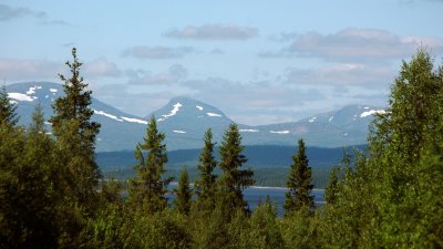
Harkantrip
The "Hårkan-trip" is our most popular route. Partially because the water levels in the Hårkan river are almost always high enough for canoeing. Passing through the swedish fjäll, lakes and forests makes for an unforgettable nordic experience. Booking a trip along the Hårkan brings a minimal risk of running into waters to shallow to paddle through, in contrast to the Storån and Långan rivers where low water levels are common, interrupting your trip.
We offer multiple starting locations along the Hårkan river:
Ulen-lake (Norway) 150 km (10 days)
The Norwegian Ulen-lake is our most remote starting location we recommend for a trip down the Hårkan. The location rests at the foot of a 5 meter tall waterfall. It is a very beautiful place with windshelter, fireplace and an outhouse.
You start your paddeling journey on a smaller river that runs from the Bergelia national park. Snaking its way through the landscape for about 2 km until you arrive on the Ulen lake. Sightings of Moose and Beaver are not uncommon here along with other wildlife.
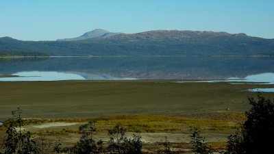
After a while you will depart the Ulen lake and paddle into the Rengen lake where the journey continues for 10 km all the way to the swedish border.
After crossing the border and continuing on for another 4 km you will find yourself at the 12 meters high Regnsfallet waterfall. Here lifting the canoes out of the water and walking is required (400 meters) to the Valsjön lake where you can set the canoes into water again. If you find yourself in need of a bed or restocking supplies there is a small camping with cabins along the water. A grocerystore as well as a gasstation can also be found here just 50 meters from the beach. If you're not in need of supplies instead paddle along the southern shore of the lake. The Valsjön lake is ripe with fish such as char, pike trout and perch. The best waters to fish are right beneath the Rengsfallet waterfall. A fishing licence is needed to fish here and can be purchased on ifiske.se where the "Hårkan fishing-card" will cover almost all waters for the entire journey at 500SEK/person/week. The exception is if you want to fish in Norway where a separate licence must be purchased at a food store in "Söril" on the Norwegian side of the border.
Camping is not allowed at the bottom of the waterfall where the canoes are put back in the water. But you are free to stay here to fish, eat, rest up for a bit and just enjoy the scenery.
The trip continues for 7 km along the southern shore of the Valsjön lake, you will pass some neat resting spots and natural places to setup a tent when arriving at the end of the lake. Here you can choose to either pick up the canoes near a sandy beach on the southside or to paddle under the bridge that crosses the stream leading from the lake. Caution is advised when paddeling under the bridge as there are alot of rocks sticking up under the surface. When arranging transports to the starting location for the 150km trip we usualy make a quick stop at this bridge to scout out the water levels.
NOTE: Fishing in Toskströmmen(the "Tosk-stream") is prohibited as this is a private fishing strip that continues down the stream.
If you choose to paddle under the bridge lift the canoe out of the water to the left at a so called "stone chest" (old stone constructions built for transporting timber downstream). Do not paddle any further as a regular canoe will fill up with water rapidly as the waters get very wild further on. After traveling on land a kilometer or two downstream with a canoe wagon or by foot you can put the canoes back in the water. There is no sign indicating the spot but it is very obvious and not hard to find. This is also the starting point for the 110 km trip.
Valsjö-village 110 km (7 days)
Starting shortly after the "Tosk-stream" NOTE: The tosk-stream is a potentialy lethal strip to navigate and should under no circumstances be traversed with a regular canoe. The stream can be traversed if you are a proffesional equipped with a shorter stream-kayak. The area after the dangerous currents is not as lethal and equipped with a nice fireplace, sadly no wind shelter though.
When continuing paddle through the gap into the Hottags-lake. On the right side there is a white church, if you are in need of supplies you can take a short detour to Rötviken-bay where there is a camping with small cabins in combination with a grocerystore just behind the camping. Rötviken-bay is also a suitable starting location for the 110 km trip.
If you instead paddle along the left side of the lake continue on the left side until the lake narrows down. Taking advantage of the narrower waters you can safley cross to the right side.
NOTE: During rough winds and weather, stay on the left side until the wind settles down and its safe to cross.
Paddle on down until you pass the starting location for the 90km trip(read below). The houses that can be seen belong to Ålviken-bay where only one family resides permanently, though there are some vacation homes littered along the shore.
Ålviken 90 km (5 dagar)
Starting on the north side of Hotagssjön-lake near Ålviken (but not part of Ålviken's society). A neat spot to start your trip inside a bay where there selldom are any rough winds.
Paddling along the south side of Hotagsskön-lake is adviced as the chance of wind is substantially lower than on the north side. There are no wind shelters along the shore but quite a few locations suitable for setting up a tent.
NOTE: There is a wind shelter on an island in the middle of the lake. You can very well paddle there during the evening when the wind is more still. There is a risk during daytime that the wind is so strong that leaving the isle is impossible untill the wind settles down later in the evening.
After about 15 km one arrives at the Hovdet-dam where the Hotags-lake ends. This dam regulates the water levels in the Hårkan river. Be aware of the water outlet by the dam!
Keep at least 25 meters distance to the outlet to avoid getting caught in the strong currents. To the left of the dam by the old outlet you can bring the canoes out of the water.
Here you'll find a large wooden table with benches to eat and rest up for a bit.
Here you are presented with 2 alternatives:
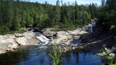
1) Walk with a canoe wagon 200 meters downstream, set the canoes into the water again and paddle on for another 600 meters (sometimes this stretch is quite rocky). Pick up the canoe out of the water again on the left side. Here you arrive at "kyrkstens-waterfall" (5 meters tall). There are no warning signs before the waterfall which some unfortunate canoers have experienced over the years after their canoe capzied after taking in to much water.
2) Walk with the canoe on the gravel road towards the main road to "Laxviken". Halfway up there is a road to the left where you'll have to pass under a bar that blocks cars from traversing. Carry the canoes another 2 km and then set them in the water again at the bottom of the waterfall.
The most comfortable choice is the first. Paddling carefully downstream and leaving the water before the waterfall. This stretch also offers great fishing, especially for trout and grayling.
Paddle and waddle on after the waterfall through Lövsjön-lake and continue down the
Lövsjö-stream.
Lövsjön-lake 60 km (3 days)
Starting point on the east side of Lövsjön. The trip from here starts with paddling on the lake for a few kilometers. After this comes the Lövsjö-stream. At a normal water level paddling down the stream is just fine if you're paddling slower than the current: paddle backwards with the paddles to slow down. If the water level is too low you can lift the canoes past the stream. Or tow the canoes downstreams by attaching long ropes to the front and back of the canoe, holding them in a tight grip and walking along the shore.
Näsaforsen-stream 50 km (2-3 days)
Right after Näsaforsen's hydroelectric plant there is a wind shelter, table, fireplace and an outhouse. A very suitable location for bigger companies to setup tents since the open area is roughly half the size of a football field. The water here is also great for fishing with chances to catch trout, grayling, pike, perch and probably also whitefish.
Continuing along the shore on the Sanviksjö-lake untill you reach Edsforsen-stream(read below) where you can either paddle through the left furrow. Or walk along the road with a canoe wagon for about 800 meters.
NOTE 1: Scout out the left furrow before paddeling. If the water levels are low it can be quite difficult to traverse. If you dont spot any rocks when scouting paddeling should be fine as long as you're going slower than the current by paddeling backwards on both sides of the canoe.
NOTE 2: Do not under any circumstances paddle down the furrow that runs along the road. The current is very powerfull and full of rocks.
NOTE 3: Dont put two or more canoes on the same wagon, it might damage damage the wagon or the canoes.
Edsforsen-stream 40 km (2 days)
A shorter route that is suitable for almost everyone. Starting at the end of the Edforsen-stream
by a wind shelter with an outhouse. Firewood can usualy be found here supplied by the fishing-caretaking-area.
The route goes through mixed forests consisting of mostly pine and fir lining the river and its rocky shorelines. Every 1-2 km you are likely to find a wind shelter. The ground at the wind shelters is mostly dry and sometimes grassy with open places which means less mosquitoes than inside the forest. In totalt there are about 15 wind shelters from Edforsen-stream down all the way to Lit. The last one is situated on Blåberget-hill around 6 km upstreams from the camping in Lit.
Dont hesitate to contact us if you have any questions regarding any stretch of the Hårkanroute. See the links for current prices.